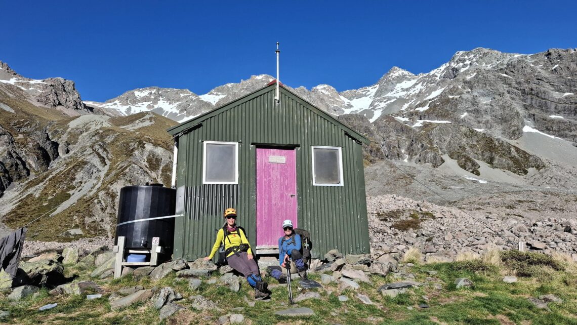
Toka Bivouac

Toka. It sounds so… romantic! Well, if you want to leave your cares behind then this may be the perfect Ruahine overnighter. In fact, I didn’t see anyone else the whole time I was on this trip.

Shorts and Knights Tracks can also be done as a solid day hike.


Shorts Track

A 10-minute warm-up across farm paddocks descends to Mākiekie Coal Creek. On the other side, a sign denotes the Ruahine Forest Park boundary. Bust out of the creek and you’ll soon come to a junction.

Turn west to head up Shorts Track. The track descends gently before veering sharply southeast, whereby it begins tracing a steepening spur. The beech forest through here is beautiful. A series of breathless zigzags lead to the junction with Deerford Lodge Loop Track, an hour from the carpark.

You are now clearly on a ridge. Generally, Shorts Track climbs easily, and the way is obvious, although the track was somewhat overgrown underfoot in January 2025. A spur at 1,200m offers great views north over the Ruahine Range and south towards Palmerston North.

Climbing up Shorts Track—a bit scratchy underfoot.

It’s not far now until you break out onto the alpine tops, just above 1300m. Views open in all directions.

The next 2.5km to Toka summit are relatively quick, with the odd spot of “puff.”

View over Shorts Track from Toka high point.

Knights Track

This is the more direct route to Toka and, above the bushline, has amazing views of Ruapehu and Ngāuruhoe. There are also great views over the big, broad summits of the Whanahuia Range, and a wonderful band of mountain cedar between the podocarp and leatherwood layers.

There is a steep climb from Mākiekie Coal Creek to the spur, but the real test is the 30%-40% gradients in the few hundred metres of track above this—the rest is plain old “generally steep” all the way to Toka.

A climb up Knights Track could be somewhat draining, especially on a warm day.

There was sumping on parts of Knights Track (where the ground cracks and potentially may slip) but the Department of Conservation had not closed the track, and this shouldn’t prevent anyone from passing through with care.

Ruapehu and Ngāuruhoe from Knights Track

Knights and Shorts Tracks converge on Toka (1,519m), a beautiful summit with views over the Pōhangina Catchment – indeed over the Ruahine Range proper – to the Southern Hawkes Bay. You also have a good chance of seeing the volcanoes of the Central North Island, and possibly Taranaki too. Toka summit is also the turnoff to Leon Kinvig Hut, although as of 2025 the hut is being repaired, having been nearly written off by Cyclone Gabrielle in 2023.

Beyond Toka summit

From Toka, a sign suggests it’s 1hr 30mins to your bunk at the bivvy, which is about right, including stops to survey the scenery or catch your breath. The route is unmarked but the ground trail is clear.

On the summit of Toka. The bivvy is 1.5 hours away along an unmarked route.

The section beyond Toka summit is where frontcountry tramping moves from “moderate” to “challenging” territory. A brief, slightly spicy sidle around the southernmost knob is fun—or maybe not so fun in wet, muddy or otherwise slippery conditions! 

You turnoff at a Pt1540m offers perhaps the best views of the trip. North along the Ngāmoko Range is Tunupō and the higher summits of the mid Ruahine Range beyond. Three rusty bars mark the high point, the highest on the trip, and navigation may be needed when visibility is poor.

The 200m descent from Pt1540m to Toka Bivouac is reasonably steep and scrambly at times and suitably endowed with springy leatherwood. It’s the most technical section of the trip, so slow your pace and take your time. The bivvy isn’t far.

Climbing through Leatherwood out of Toka Bivouac.

At 1,300m elevation, Toka Biv sits quietly in a marshy basin below the Ngāmoko Tops. There’s a tap with water, and a thunderbox with a fine view. Hut book entries indicate only two or three people seem to pass each week so you’ll likely find Toka unoccupied. It’s an amazing place to light a candle, look up at the Milky Way, and forget about the world.

Sunrise at Toka Bivouac.

Need to know

Access: Drive to the carpark at the end of Limestone Road.

Grade: The Shorts-Knights Loop is “moderate”, whereas the way beyond Toka summit over the tussock tops follows a ground trail and is better thought of as “challenging”. The trail from Pt 1540m down to Toka Bivvy is steep.

Time, distance and ascent: Carpark to Toka Bivouac via Shorts Track (5hr, 9.82km, 1,232m); Toka Bivouac to carpark via Knights Track (4-5hr, 7.67km, 472m). Total distance is 17.5km and total ascent is 1,704m.

Accommodation: Toka Bivouac (free, two bunks). There is mobile coverage here.

NZ Topo 50: BL36 Norsewood

Tip: If you like this trip, or are looking for a similar trip, check out Ngāmoko Tops Circuit.

Check out the view from the “thunderbox”!

Map

https://www.topomap.co.nz/NZTopoMap?v=2&ll=-39.983183,176.072268&z=13&pin=1